
Israelis Prepare for Major Snowstorm 2015
By Yotam Rozenwald

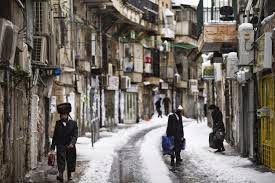
Israel is preparing for the first snow storm of the 2015 winter. Meteorologists predict that this year’s storm will reach its peak on Wednesday morning, January 7, covering Jerusalem and the Benjamin region, and then spreading south to the mountains of Gush-Etzion and Hebron. Snow is expected to fall throughout Wednesday night, and will dwindle on Thursday. The cold weather will include rain, snow, strong winds and freezing temperatures, and is expected until Sunday morning of next week, with the possibility of light snows falling on the weekend.

.jpg)
The 2013 ‘Alexa’ storm generated heavy snows in the high mountain terrains of Jerusalem,

Weather buffs have come up with predictions of accumulations of 2-6 inches in Jerusalem on Wednesday and Thursday. It appears that all areas 600 meters (2,000 feet) above sea level will see the white stuff pile up. Snow may fall in lower-lying areas, even in Modi’in halfway between Jerusalem and Tel Aviv, but it will not accumulate, according to current weather maps. The prediction for Gush Etzion , which includes hills higher than Jerusalem, is for 6-10 inches. On the Hermon ski slopes, 3-5 feet will fall, and 1-2 feet will dump on Tzfat
 (Safed). As usually, snow accumulation predictions have to be taken with a grain of – uh – snow because a change of one degree here or there is significant. The amount of snow in Jerusalem and to the south depends on how far and how fast the storm system moves southward. In any case, the storm will be previewed by a sudden drop in temperatures Wednesday afternoon and will leave behind freezing weather. Residents are advised to be prepared for electric outages due to heavy demand for electric and due to gale-force winds, which are likely to tear down trees and power lines. Current maps show that a re-rerun might be in store for next week. Last year, a huge early winter storm dumped accumulations far beyond what was predicted.
*****************************
Snow Forecast Update: Brace for Gale Force Winds
Snow will fall at altitudes as low as 2,000 feet above seas level. Accumulation in Jerusalem still a question mark. By: Tzvi Ben-Gedalyahu | Published: January 4th, 2015

The updated forecast as of Sunday evening in Israel point to heavy rains on Wednesday, with winds of up to 65 miles an hour, and snow in the evening at altitudes of 2,500 feet in the northern Galilee and Shomron. The storm will spread southward Wednesday, temperatures will drop and snow will fall at altitudes as low as 2,000 feet, which includes the Lower Galilee, Jerusalem, Gush Etzion, the southern Hebron Hills and Mitzpeh Ramon in the central Negev. The storm will weaken on Thursday but will leave behind very cold temperatures. This storm is a bit of a fooler. The temperatures on Tuesday will change very quickly in the afternoon and will catch doubters off guard as the thermometer heads for freezing. The snow will be heavy in the north, and large amounts of hail are forecast in low-lying areas. As for amounts of snow in Jerusalem, tune in tomorrow. It is too early to know right now. What is certain is that flash floods will rumble down the Jerusalem and Judean Hills into the Jordan Valley and Dead Sea.
This is unofficial and bit too long-term to be considered certain, but there is chance of another snowstorm next week.
********************************
Operation Eye of the Storm

Tomorrow (Wed) storms will be noted throughout the country. Forecasts say that by tomorrow afternoon it will begin snowing in Jerusalem and in mountains and communities that are higher than 600 meters. The snow is expected to continue falling until Thursday morning. There is a chance that it will snow again in the mountains on Thursday night. The Jerusalem Municipality has announced all educational institutions will be closed tomorrow and Thursday due to the storm. Meanwhile in Petah-Tikva, at least 200 houses and apartments are disconnected from power due to a tree which collapsed on a high-voltage electricity pole. The military, police, fire department, the Electric Corporation and local councils have finished preparing for the storm, which has already begun today with strong winds and dust storms.
.jpg)
The police are calling on the public to drive with caution near water reservoirs where there is a danger of falling, drifting, and drowning. As such, they are also calling on the public to drive according to the conditions of the roads and to avoid traveling on roads where there is flooding, to keep distance between cars, and to drive slowly.
Traffic police decided to close the main arteries in Jerusalem and the roads leading to the city - Route 443 and Route 1---on Wednesday before the snow builds up, in order to avoid stranded cars. In Jerusalem, they added new snow plows and rock salt. They are prepared with means of heating and food.
.jpg)
No comments:
Post a Comment